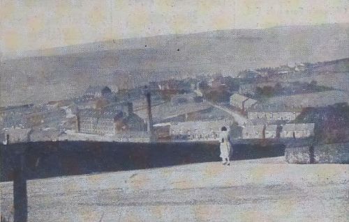
Picturesque Glossop and Longdendale 1937/8.
In 1937/8 The Glossop Chronicle and Advertiser published a series of “photographs of interesting and beautiful places in the Glossop and Longdendale district”. This article contains scans of the photographs and transcriptions of the comments published alongside them, together with links to other articles where appropriate.
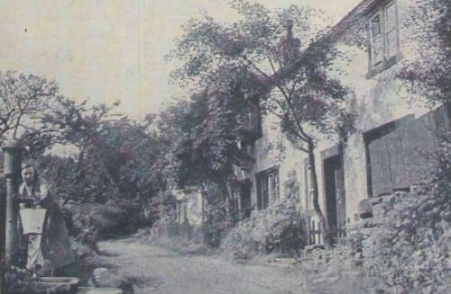
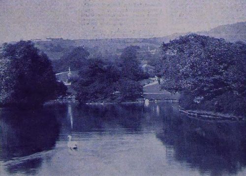
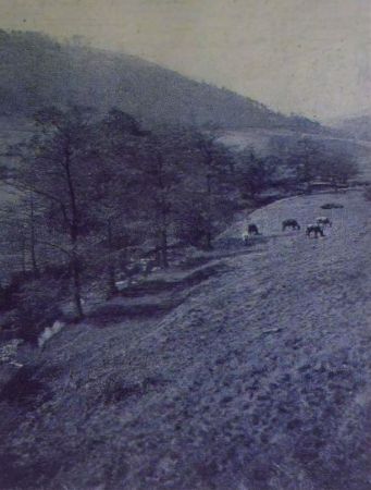
The Gnat Hole.
Here is the first of a series of photographs of interesting and beautiful places in the Glossop and Longdendale district. To quote the B.B.C. “We hope to bring you something interesting each week”. This picture is easily recognisable – the Gnat Hole, one of the most charming spots in the neighbourhood. It is off the Buxton road, Glossop. Had this been in the Isle of Man it would have been boosted as a glen, and probably you would have paid to walk through.
The old mill, now almost in ruins, was once a prosperous woollen mill which turned out a high-class product. It closed about 60 years ago. Some of its stone is now in the new pavilion built by the bleachworks for their employees' sports ground.
The old mill is said to be haunted by a person referred to as “Old John,” who ended his life in a part of the mill which Farmer Z. Wood now uses as a goose cote. Weird knockings have been heard in the mill.
Round or through the Gnat Hole is a favourite lovers' walk. Local Romeos take their Juliets through this lovely glen, but it is not monopolised by lovers.
Much of its beauty has gone. All that remains of the Gnat Hole Wood, with its fine birch and fir trees is a few stunted growths.
For more information about Gnat Hole see the article Gnat Hole - a Woollen Mill in a Cotton Town..
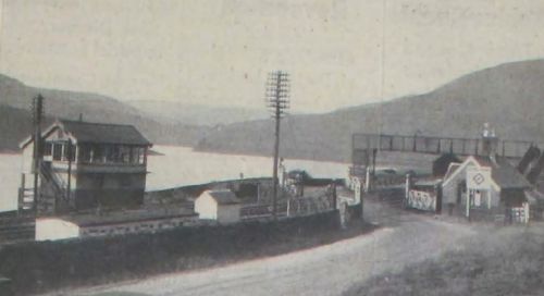
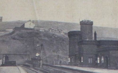
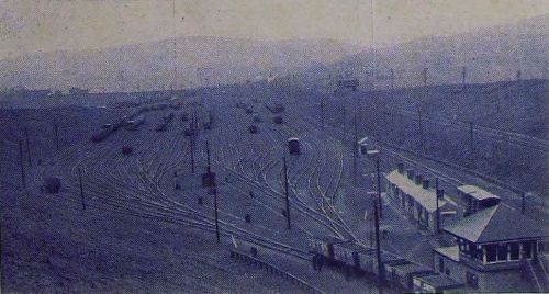
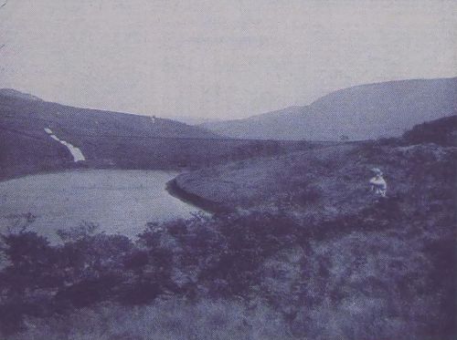
Torside Crossings.
The view shows Torside Crossings with one of the Manchester Corporation reservoirs stretching away in the background, and a goods train climbing the gradient to Woodhead on its way to Sheffield.
The origin of the name Torside Crossings is simple. They are at the side of the “tor” or hill.
The average daily rail traffic over the Crossings - which are on the L.N.E.R. main line between Manchester and London - is 280 trains and it is rather awe-inspiring to watch a London fast glide from behind the hill higher up the line and flash by on its way to Manchester.
“You can double that figure of 280 for the number of road vehicles which go over the Crossings” said a signalman who works in the box seen on the left of the picture. They are mostly private cars for the heavy goods traffic is mainly along the Cheshire side through
Tintwistle.
The quaint looking house on the right is a relic of the original line - the Manchester, Sheffield and Lincolnshire Railway. It was the gate-keeper's house.
The signal box was then on the opposite side of the line to where it is now and the signalman only looked after his signals, the Crossing's gates being the responsibility of the gate keeper. Travellers had to call him from his house to unlock the gates. Now the gates are opened by the signalman in his box.
Torside Crossings is a favourite turning point for pedestrians, cyclists and motorists. How often does one hear the remark, “Let's have a walk as far as Torside” whilst the lovely free wheel from Devil's Elbow to the Crossings, with a glorious view of the valley all the way, is ample compensation to the cyclist for the hard pull on the way back, And how many motorists are there in Glossop whose first experience reversing and turning was not accomplished at Torside after they had got the feel of the wheel on the straight on Woodhead road?
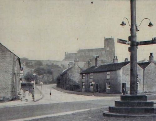
Mottram Church - The Cathedral of N.E. Cheshire.
Even the de-restriction signs which obtrude themselves at you cannot take away the beauty and grandeur of this picture of Mottram Church, the Cathedral of North-east Cheshire, as it is known. Standing on the highest part of the hill on which the village is
built, the church, dedicated to St. Michael and Holy Angels, is seen from different points for miles around. It's a climb up to the churchyard, but there's a reward with the view from the top, particularly on a clear day.
The church is built of very hard, pebbly stone, very durable, which, according to tradition, came from Tintwistle. Tradition also says that the mortar or cement used in building the church was mixed with strong ale, which was brewed In a booth or shed at the
“church stile.”
The body and chancel of the present fabric replaced a former one of wood and plaster in the 14th century. The tower was built about 1487 as appears by the will of Sir Edmund Shaw, Lord Mayor of London, who bequeathed a sum of money for its erection.
Noticeable is the work in the Chapman Chapel, which the present vicar, Canon M. Power, has had carried out.
Out in the churchyard the visitor finds plenty of interesting epitaphs, including one which tells of the depredations of "body snatchers" for medical purposes.
Before you come down in the village again, stand on War Hill, where, it is said, a great battle took place between the armies of Queen Maud and King Stephen. According to tradition, the first church on the present site was erected in memory of this battle.
In the picture you can just get a glimpse of the Crown Pole. The present one was given by the late Mr. Harold Chapman. It replaced an oak one, rotting away, given by a Lord Tollemache.
To mark Mr. Chapman's gift, what is known as the Crown Pole Commemoration Committee was formed. They gave Mr Chapman, at a dinner party, a true-to-scale replica of his gift with a silver pole, bronze base, gold cock, and direction signs, just as they are on the Crown Pole. They meet every year on the first Friday In July, no new members are
admitted, and the annual dinner will be kept up until all the members are dead.
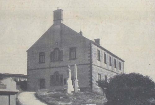
Charlesworth “Top” Chapel.
Last week our picture was of the highest church on the Longdendale side of our area. This week we see the highest on the Glossop-Dale side. It is the Independent Church at Charlesworth - or should we say Charlesworth “Top”? - Chapel.
The first chapel was built in consequence of a pious vow and dedicated to St. Mary Magdalene. This chapel is mentioned in the King's Book (Valor Ecclesiasticus, 1535). History tells us that it was a lowly pile, with a roof of peculiar construction, formed of bent
timbers “resting on the floor on crucks” and meeting at the top in a pointed arch. The story goes that this roof was of Irish oak, and neither spiders nor any kind of vermin were ever found near it.
The chapel was deserted after the Reformation, and sheep and cattle used to shelter in it. It came into the possession of the Independents about 1736. A century or so later it was pulled down and the present church, shown in the picture, built on the site.
Mention was made last week of the stiff climb to the Mottram Churchyard and the reward of the glorious view. It is a stiffer climb to the “chapel yard,” as the villagers say, but the reward is just as good. On “Sermons” Sunday it is a wonderful sight to see the gorgeous
blooms which are placed on every grave.
The hold which the “Top Chapel” has over its people is peculiarly its own. They come from all over the country on “Sermons Day,” and the wills of people, who left Charlesworth in their prime to advance in the world, have contained phrases like “and that I be buried in the chapel yard in my native village of Charlesworth.”
And now for the vow which led to the erection of the original chapel. During autumn, long 'way back in olden times, a lone traveller was walking over the moors, hoping to reach some town or village before night fall. Suddenly a mist came on and he lost his way, straying into the wildest and most dangerous part of the moors. The traveller, to quote the historian, wandered up and down, vainly endeavouring to win his way off the wild moors, till night, all at once came on with more than wonted gloom.
Not daring to proceed any farther in the dark; filled with dread at the dreariness, perhaps peril, of his situation and perishing with the cold clinging mist, he prayed to God and his patron saint for protection and vowed to build a chapel on the moors if he reached safety. He had scarcely breathed his prayer when the mist cleared away, the moon shone out and the darkness vanished. As he was breathing his thanks to Heaven and marvelling at this answer to his prayer, a shepherd came along driving a few sheep, who led the traveller off the lonely moors to his master's house, where he rested for the night. Having arrived safe at his home in Ireland (the historian concludes) he came again after a while, bringing with him an oak timber roof and on the brow of these moorlands built the chapel in fulfilment of his vow.
For more information about Top Chapel see the article Charlesworth Independent Chapel Triple Jubilee Commemoration 1798 – 1948..
Woodhead Tunnel – A triumph of engineering.
Many people who have visited the picturesque station at Woodhead will appreciate this view of a goods train emerging from the famous tunnel. Two seconds before our photographer took the picture the mouth of the tunnel could not be seen. It was wreathed in smoke, though not one wisp was coming out of the other mouth.
The reason is this, As soon as a train enters one of the tunnels, it pushes the smoke out in volume at the other end, clearing it away like magic as it thunders out of the tunnel mouth.
Woodhead Tunnel was built about ninety years ago and is three miles twenty-two yards long. It is the second longest on the English railway system. The distinction of being the longest belongs to the Severn Tunnel, which takes the line from Bristol, under the River Severn, into South Wales.
Woodhead Tunnel is never clear of smoke but don't believe the stories you have probably heard about the drivers and firemen having to lie down in the engine cab as they travel through. They are not true. What the men do, as a general rule, is to put a damp handkerchief over their mouths. Pity the poor platelayers who have to work in the tunnel!
Woodhead Tunnel is really a misnomer. It should be tunnels, because there are two distinct tunnels, one for the up and another for the down line. This triumph of engineering has stood the test of constant friction and smoke remarkably well, due almost entirely to the manner in which it is cared for by the railway people. Accidents in the tunnel have been comparatively few, though when the line was being widened lower down many years ago
there were several fatalities.
The next time you are up at the “tunnel mouth,” as the familiar phrase has it, make your way down to the little station, whose buildings resemble some medieval castle, and wait for a train thundering out of the tunnel. The sight will impress you - awe you almost. Looking at this picture gives you some idea of the feeling which comes over you.
Here's an after-thought. There is no Angel Inn now at the “tunnel mouth,” and the George and Dragon at Crowden is the nearest place where you can quench your thirst if you have footslogged it to the “tunnel mouth,” or where you can “water your engine” if you have driven up by car.
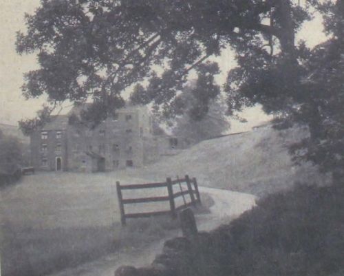
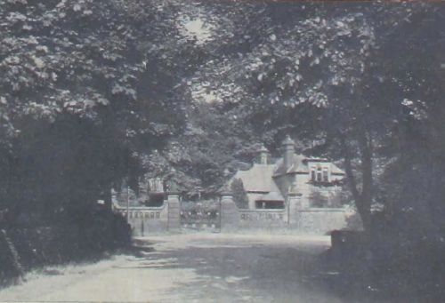
Moorfield House, Glossop.
Here is a charming picture of the avenue of trees facing the drive leading up to Moorfield House, Glossop. Have you ever noticed how charming this scene is? Probably you haven't, and it has been left to the camera to show you.
Moorfield House, of which you can catch a glimpse from the lodge gates, was built by the late Mr. Daniel Wood when he and his two brothers, John and Samuel, were the owners of the Howardtown Mills. Each day Mr. Wood used to ride down to the mills on a steel-grey cob, which was often tethered at the mill gates awaiting its master.
On the death of Mr. Daniel Wood, the late Mrs. S. Wood, mother of Sir Samuel Hill-Wood and Glossop's first woman freeman, removed there from Talbot House, Glossop. “Young Sam,” as Sir Samuel was then known, had a cricket pitch laid in a field just outside Moorfield gates, and here the employees on the estate played club games under the name of Moorfield. Sir Samuel brought many well-known players for the matches.
When his mother died Sir Samuel took over Moorfield which during the war was converted into a convalescent hospital for soldiers. Many a “Tommy” is now a happy family man in his adopted town of Glossop through coming to Moorfield in hospital blue.
After the war Sir Samuel again settled in Moorfield. Eventually he took up residence in London, and leased Moorfield to the Catholic authorities, who set up a small seminary under the title of St. Michael's College.
After a couple of years this finished, and the house was unoccupied. Whilst it was unoccupied a disastrous fire occurred. and considerable damage was done to the house.
Mr. Josiah Jackson, of High Lawn, purchased Moorfield, made good the damage, and is now in residence there.
Now the next time you have a walk round Moorfield, look at this lovely avenue of trees, and you'll find that it's just as beautiful as our picture shows.
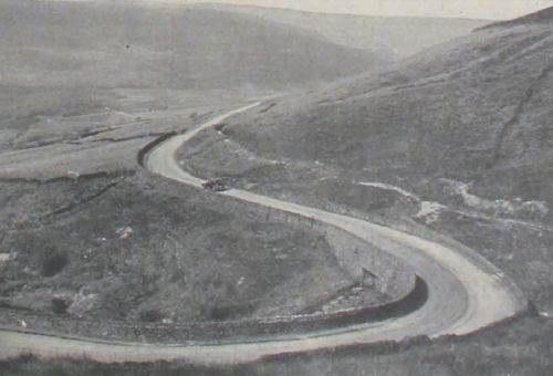
The Devil's Elbow.
Had we been betting people, we could have offered you big odds that you did not know what this week's picture showed until you saw the headline.
It's the Devil's Elbow from a new angle, and our photographer was rather out of breath after climbing up the rough moorland to get this “new one on Devil's Elbow.”
The picture gives you a better idea of what the corner really is than you have ever realised, whether you be a car driver or a hiker.
The swift-flowing clear stream on the top side of the Elbow is easily seen. Many of us recall how, when we were on summer holidays from school and on a walk to Torside, we have pulled off our shoes and stockings, sat on the bank and dangled our feet in that icy cold water.
Down below is seen the road between the Longdendale reservoirs leading to the Cheshire side, and all around are the quiet hills.
Not so quiet these days, though. It was the “Glorious Twelfth” on Thursday, and for some time the hills will re-echo with the “bang, bang” of guns, for these moors round Woodhead provide some good sport.
Often we have wondered why these tortuous bends up and down the country should be called “Devil's Elbows.” Who knows whether Old Nick's elbow is like them?
Absent from the picture are figures whom one is sure to see up at the Elbow ninety-nine times out of every hundred. It must have been the hundredth occasion when the picture was taken. On the other ninety-nine you will find (1) pedestrians leaning over the wall, admiring the glorious view stretching before them, and (2) sheep grazing on the moorside or causing motorists to pull up while they cross the road to find a new pasture.
The Elbow has not always had as good a road or as good a wall as it has now. When the water rushed down the gully during the great storm a few years ago, it swept away the road and the wall. Repairing it, the County Council widened the road, improved it,
strengthened the wall, and improved the tunnel, which runs under the road to guard against the danger of subsequent floods.
By the way, there was a slip of the pen, a printer's error, or any other of those “naice” ways of saying “mistake,” in last week's picture. It was stated that Mr. Josiah Jackson, of High
Lawn, purchased Moorfield. It was his brother, Mr. Frank Jackson, of High Lawn, who did so, and who now lives there. Mr. Josiah Jackson lives at Redcourt.
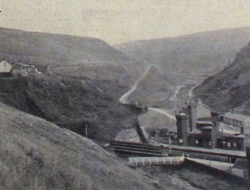
The Wild Beauty of Woodhead.
Recently we published a photograph of Woodhead Station. Here is another view taken from the main road above the station.
It shows the station, the railwaymen's cottages, and a now sluggish mountain stream in the bottom, the big hill leading from the A.A. box in the background, and, overshadowing all, the moors.
The stream is not always as sluggish as the picture shows. In the winter time it bubbles over its boulder-strewn bed and cascades over falls.
You can see “teas” painted on the roof of one of the buildings on the left. How times change! Not many years ago, had you said in those buildings, “May I have a cup of tea, please?” people would have stared at you with all the eyes in their heads, as we say, for
then it was a flourishing “pub.”
This bit for the kiddies. Some of you don't like getting up at eight o'clock in the morning to be ready for school at nine o'clock! Well, some children live in those houses you can see in the picture, and they have to get up earlier than you to get to school. A motor coach takes all the Woodhead and Crowden children and those who live in the lonely farmhouses you have seen up in the district, every day to school at Tintwistle or Hollingworth, and takes them back home each afternoon. You'd probably like that part, but not the early getting up. And then, another thing, Woodhead children can't run off to the pictures as easily as you can.
Woodhead is so called for its being the head of the great forest which formerly existed here. Mention is made of this in the Earl of Chester's survey made in the time of King Stephen “Silva in Tingevisie est quatuor leuces longa et undecim lata” which translated is: “The wood at Tintwistle is four leagues long and eleven wide.” So thick with trees in the vale of Longden in olden time that, according to tradition, a squirrel could leap from tree to tree from Mottram to Woodhead.
The author of Vale Royal, in 1596, described Woodhead as “a place well-known to those weary travellers who come over these mountains and craggy ways in Yorkshire.” It is equally well-known to travellers now who are whirled through, comfortably enough, on the
railway or by car and less comfortably, in the big transport vehicles which form an almost unbroken stream during the twenty four hours of each day.
One always considers the hill shown in the picture as one of the most treacherous ones on this stretch of road.
For want of a better description, it can be called a “tempting hill.” After rounding the bend at the top, one always feels inclined to “let her go” down into Woodhead, but the acute left hand bend at the bottom restrains one. It can't be taken safely at a fast speed. More than one car or transport wagon has careered off the road and down the ravine, the height of which is clearly shown In the picture. Many more would have run off the road during darkness had it not been for the reflecting posts which the County Council have placed every few yards down the hill.
The Hague.
This photograph is of Broome Cottage at The Hague, Broadbottom. Could you blame yourself, or could anyone blame you for thinking, on your first glance at the picture, that
it was taken in a leafy-lane somewhere in Devonshire?
The more this series progresses the more we are convinced that we have not realised the beauty of our own countryside. Because we are finding these pretty places week after week, we enjoy writing these notes. This charming spot is less than half-an-hour's walk from crowded roads and the “raucous voices of the multitude”.
If you haven't been round The Hague, see it before winter comes.
Turn in at Carr House-lane in Mottram Moor and you will come out in Gorsey Brow, Broadbottom, after one of the nicest walks you could imagine.
If The Hague had been “somewhere in Devon,”" you would come home and rave away to your friends about the beautiful walk you had. The Hague is as charming as anything you will meet in Devon.
But don't do as we did. We went by motor car, but never again. Even in this modern age, The Hague remains truly rural, as far as travelling along it by motor car is concerned. What with the boulder-strewn road and the getting out of the car to open and shut gates, the experience was not happy. We walked round later, hence the enthusiasm.
Yet in this truly rural neighbourhood science has protruded, for pylons rear up amongst the charming surroundings and the loneliest cottages have electric light.
As you start your walk, you pass the Isolation Hospital for the Longdendale area, which has not had a patient for about quarter of a century. Happy state of affairs! And on through farmyards, with lovely views of the Glossop and Charlesworth sides all the way along.
Round here, too, is the old Mottram Golf Club's course. It seems a pity that such a splendid little course in such a charming setting should not be in use.
It has been said that the numerous mounds round The Hague are tumuli – the resting place of our ancestors in Saxon days, but this is doubtful, in fact.
If you want to gather bluebells, go round The Hague in bluebell time.
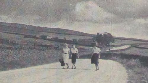
Chunal.
There is a breath of fresh air about this photo, and a sense of spaciousness, as the girl hikers who are making their way to Glossop Station after a circular ramble, would agree.
Prominent in the picture is the Grouse Inn. Once it was quite a convenient establishment when the three-mile limit law was in operation. It is still a popular rendezvous, as it is a nice walk out from Glossop on a summer evening.
Just beyond is Hollingworth Head. That's what it's called on a map, but if you asked anyone in Glossop where Hollingworth Head was, they'd be rather at a loss. They might perhaps, direct you to Hollingworth, and tell you to make further inquiries there. Ask for "Holli'oth Head," and straight-way they will send you up Chunal.
Chunal itself is an ancient farm hamlet which Richard Foljambe and John Holt granted to the Abbey of Basingwerke in 1336.
Hollingworth Head is the verge of the old Glossop estate.
Before you drop down the Head, a road is seen going towards the right. Follow it, and you will reach Charlesworth.
Locally, it is known as “Monk's Road.”
Of it a local historian writes: “In this road and in several objects around, the memory of the monks of Basingwerke is preserved in a way quite remarkable.”
The road was used by the monks on their way from their abbey in Wales to their manor of Glossop.
On the road is an ancient block of stone, curiously scooped out at the top and bottom, like a rude seat or chair. It is called the Abbot's Chair.
As a matter of fact, when Chunal was granted to the Abbey in 1336 it was placed as the boundary mark of the abbey lands.
Here, tradition says, the Abbot of Basingwerke used to hold a kind of open-air court for the manor of Glossop.
Have a walk round Monk's Road and you will be compensated for the hard pull up Chunal. The air is invigorating and the moorland views wonderful.
The Road to the Moors.
To those who recognise this picture immediately, the title might seem a little “high falutin'.” They will say, “It's the Wharf.” The postal authorities call it “Shepley Street, Old Glossop.” All of us will be right.
This scene is familiar to Manchester ramblers who go along The Wharf to reach, by way of Mossey Lea, Doctor's Gate and the moors.
The bridge over the Glossop Brook, at one time conveyed loads of wood from the estate Saw Mill of Lord Howard on the opposite side of the road to the yard across the brook.
Clearly seen is “Sammy's Mill” and the “bant walk” where, at one time, it is claimed that the finest ropes in the world were manufactured.
Further along there is the site of an old cotton mill. Then you pass the former tanyard and beyond that is the place where the old Bone Mill used to stand. That quarter of a mile must have been a hive of industry in former days.
Some years ago a correspondent said he looked forward to the time when all the old houses would be superseded by modern villas, and trees would grow on the brook banks where now clothes line posts rear up. And should we say when the ducks nearly always seen (some can be seen in the picture) have been substituted by swans?
“Racing at Glossop”. Had one of the Duke of Norfolk's ideas materialised there might have been a headline like hat in the racing press. He intended to construct a racecourse round
Mossey Lea and was building a tower on the top of Shire Hill (seen in the picture) to enable him to see all round the course. The foundation of that tower can still be found on Shire Hill.
On the hill at the back of the picture is the old rifle range of the Glossop volunteers.
And so round Mossey Lea to Doctor's Gate. The reservoir reminds one that about a thousand wild duck each year were reared there by Lord Howard, whose gamekeeper at the Tanyard also raised annually about 2,000 pheasants.
Mossey Lea - with its sombre hills and gloomy valleys, covered o'er with dark heath and whinberry bushes, relieved here and there with the beautiful “flower of broom,” the bright green of the fern or patches of greensward - a pleasant walk and one much appreciated.
Here is the legend of how Doctor's Gate - the gateway to the moors - got its name. Dr. Faustus, riding at midnight on a coal-black steed, met the arch-enemy of mankind to deliver himself up, but that he persuaded Satan first to ride a race with him and to pave a certain part of the road as he went. This, however, was rather too much even for the Devil, and just as Satan was at his heels, the doctor crossed the running stream, and so, according to the laws of sorcery, the enemy had no more power over him. *
The doctor's poor horse suffered, for in Satan's attempt to capture his flying prey the poor nag's tail was pulled off.
The Doctor's Gate road is set down by archaeologists as a part of the paved Roman road from the camp of Petuaria (Brough) to Melandra.
[* “If you can interpose a brook between you and witches, spectres or fiends” says Sir Walter Scott (notes to Lady of the Lake) “you are in perfect safety.”]
So if any of you ramblers plan a midnight “hike” over Doctor's Gate and meet Old Nick on the way, run like the wind and jump over Glossop Brook.
Simmondley.
This is an old-world place where some of the finest dogs which have ever followed a trail were bred by "Big Sam" Dewsnap at the Hare and Hounds Inn.
Extensive views of the countryside for miles around can be obtained from Simmondley. In this picture, for instance, the Castle stands out boldly in the background.
In the cloudbursts of a few years ago the village suffered extensively. Torrents came roaring down the Dingle, and also down past the farm where Mr. Cranmer formerly lived. Parts of the roadway were swept away at that point, and the Dingle was like a shambles.
A service was done to the villagers when the old well in the centre was covered in and the roads throughout the village were put in an excellent state of repair. It seems to have done away with a lot of flood danger, besides making it fit to visit Simmondly after heavy rain.
It wasn't before, unless you were prepared to scrape dirt off your shoes when you reached home again.
“Round Simmondley” is a favourite walk, and a very pleasant walk it is, too.
Simmondley means Simond's pasture.
There is an old hall, Simmondley Hall which was built in the time of James I.
Simmondley is also the home of Mr. H. R. Band, whose frequent travel articles, under the name of H.R.B. Are much appreciated by readers.
Hidden away at the edge of the Nab, Simmondley still continues on its old-world way.
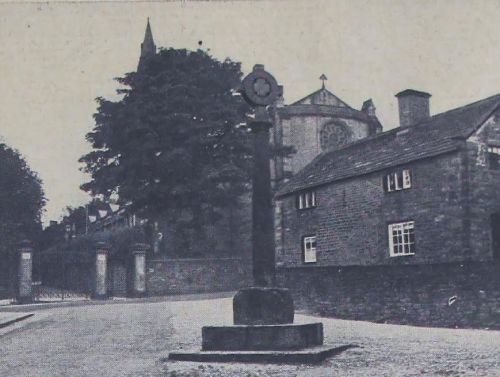
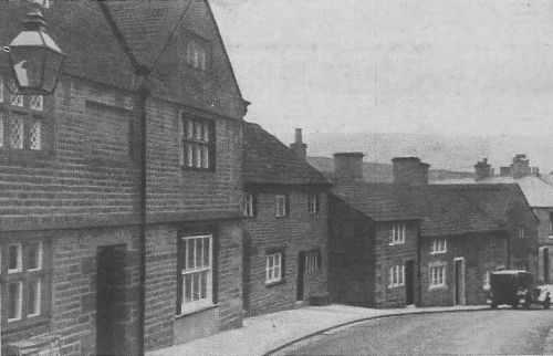
Old Cross, Old Glossop.
This picture should revive happy memories for “Anon,” our correspondent on the series last week. It is of the Old Cross at Old Glossop with Glossop Parish Church in the background.
All Saints' Church, as the Parish Church is called, was in existence before the Domesday Survey was made in 1086, but there is no documentary evidence to prove at what particular period it was built. Seeing, however, that Anglo-Saxon nobles lived in Glossop, a church may have been built on the present site at a very early period.
The registers date from 1620.
The tower was rebuilt by the Duke of Norfolk in 1856. In 1831 the body of the church was rebuilt, but it was entirely rebuilt again at the outbreak of the war, and now the tower is the only old-looking part.
Rev. F. J. Edmond is the present vicar. There was once a vicar called Onion. That was in 1620, and in 1651 Rev. William Bagshaw, called the “Apostle of the Peak,” was ejected from the living for Nonconformity. In his farewell discourse, he lamented that “on account of his principles he is driven from his beloved Glossop.”
This Cross has not always been on its present site. Previously it was nearer to the house straight opposite the church gates. This is the old manor house and the Cross is really an old market cross, round the steps of which the market folks used to expose their butter for sale. A new part at the top was added for the purpose of decoration and has been illuminated by electricity.
Old Cross has seen many joyous gatherings. Many a set of lancers has been danced there in the not so long ago, and of later years it has been the centre of activities at the wild week-ends at Old Glossop.
In the picture will be noticed the gates leading to the “churchyard.” What a terrible inconvenience it would be to hundreds of people if there were no public right of way through there and “top o' t town” had to be used by everyone.
The Pyegrove.
As long as Glossop stands Pyegrove will always be regarded as the birthplace of Glossop
sport.
This photograph is of the end of the walk across the fields from the Old Glossop end and includes “Pyegrove House” which is a landmark visible for miles around.
Built by Lord Howard for one of is employees, it is now in private hands. One rather admires the fact that it refuses to lose its old-world appearance and still relies on “white-wash” for its outer covering. It is mainly because of this that it is such a prominent landmark.
The house on the left is of only recent origin compared with the White House.
Across the Pyegrove is a charming walk on a summer's evening as hundreds of Glossop people know.
Pyegrove saves a detour round Sheffield-road for scores of people.
At one time Pyegrove was the town's gathering ground for sport, agricultural shows, and Wild West shows.
It may be interesting to the younger people to know that long before there was such a term as “O.K., chief” and long before a real he-man of the screen rasped out, “So you won't talk, eh?” the real Buffalo Bill pitched his tent with a crowd of cowboys and Indians on the Pyegrove.
They rode about the town in full warpaint, gave a real Wild West show on the Pyegrove and - what about this, you boys who thrill at the exploits of Ken Maynard on the screen -there was a bit of a “shoot-up” in a local hotel.
So you see, Pyegrove has had its moments long before “talkies” or even “silents” came into vogue.
Always Pyegrove has been regarded as a recreation ground, but in the last few years it has not been used as much by the youth and schoolchildren of the town as formerly. In this drive for national fitness, surely this big field could be made adaptable for recreation purposes! It is noticed that last month, the responsible committee of the Town Council decided to have it mown.
Going along Pyegrove, one's attention is attracted by the big stone underneath the hedge. It has been there as long as one can remember, and not even the oldest inhabitant knows how it came to rest there.
Most popular opinion is that it was left there by the sea in some prehistoric period.
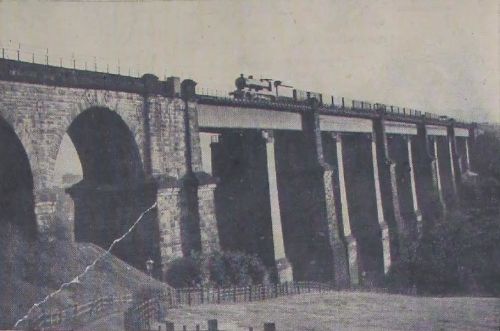
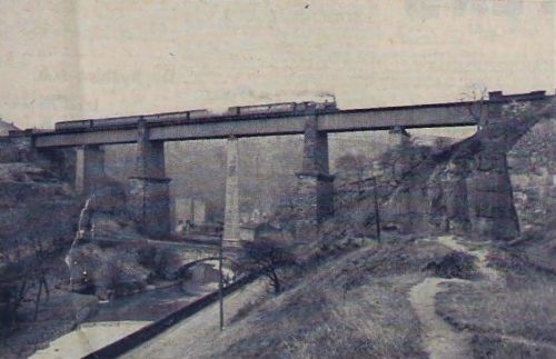
Dinting Arches.
There is something splendid and majestic about Dinting Arches which entitle them to a place in this series.
No picturisation of the two dales would be complete without including this landmark.
What a thrill the arches can give! Perhaps you have never experienced it. Be away from here for, say, six months, and experience the thrill there is when, riding over the arches, you see “home” again, stretching out on both sides as far as the eye can see.
Both Glossop Town Council and Charlesworth Parish Council have been asking the railway to provide a station at Gamesley. It wouldn't be the first; there has been a station previously at Gamesley.
As a matter of fact, it was the terminus of the Sheffield, Ashton, and Manchester Railway, the first train running to there early in March, 1842.
It was on August 8th, 1844, that the first train passed over Dinting Arches from Gamesley to Woodhead.
The height of the arches from the river bed is 121 feet, and the length of the viaduct is 486 yards.
In the 'seventies there was a shocking accident. In those days - it was before the Glossop branch line was opened - the down platform at Dinting went straight to the arches.
A portion of a Sheffield train pulled up beyond the platform. Either one or two Glossop people - the number cannot be definitely ascertained now - got out, thinking they were at the platform, and were hurled to death. There were no rails as there are to-day.
Of course, we all know that the arches are on the L N.E.R. main line between Manchester and London, and during the war soldiers constantly guarded them, the authorities taking no chances of the enemy destroying this important line of communication.
For more information about the early railway layouts see the article Gamesley and Dinting Railway Layouts 1850-1900..
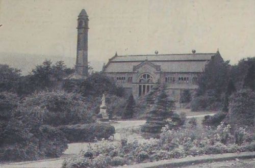
A View in Howard Park.
Taken from the site of the old bandstand, this picture gives a fine view of the foliage-surrounded Baths, and for that reason might aptly be called a "jubilee" picture.
This year the Baths celebrated their golden jubilee, and that, if you like, is a jubilee within a jubilee, because the Baths were built to commemorate the golden jubilee of Victoria as Queen of England.
They were one of several gifts to the town for a similar purpose. Mr. and Mrs. S. Wood, of Talbot House, paid Ł15,000 for their erection.
Great care was taken with the design of the ventilating tower, which rears up in the picture to secure elegant outlines in its general mass and shape to harmonise with the Italian style of the main building.
Nine feet square at the base, the tower is one hundred feet high.
The baths are reputed to be amongst the best municipally-owned baths in the north. This is largely due to the filtration plant the Corporation installed a few years ago.
Other gifts to the town at the same time were the Park itself, Wood's Hospital, and the Victoria Hall.
Wood's Hospital, also in the Park, cost Mr. Daniel Wood, of Moorfield, Ł5,000, and a further Ł20,000 for endowment.
It was a great day when the foundation stones were laid at the Baths and the Hospital on July 30th, 1887.
Several trees were planted in the Park, one by Master S. H. Wood, later always referred to as “Young Sam,” and now a knight of the realm-Sir Samuel Hill-Wood.
He made a great hit at the tree planting ceremony by saying he and the tree were the same - Wood; they were both young and they both wanted to grow.
Lord Howard gave the land for the Park, which is acknowledged to be one of the most beautiful parks over a large area. We, with it always at our doorstep, don't appreciate it as we ought; visitors enthuse about it.
Since Manor Park became public property, however, and the novelty of its accessibility has worn off, Glossop's first Park comes in for more appreciation, particularly by those who want to get away from the madding crowd.
In summer, its flowers, its rich foliage, its well-kept lawns, its babbling brook and waterfalls, its quiet pools, its birds and its quietude, are a fine respite from this noisy and rush-maddened age.
Originally, its name was Victoria Park in honour of England's then reigning monarch. It remained so until Manor Park was named, and then it became known as Howard Park.
Thus is perpetuated the name of the former lord of the manor.
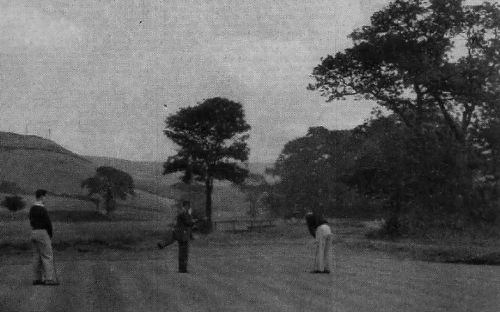
Glossop Golf Course.
Though the Glossop Golf Course is a charming course in itself, it is included in this series because of the beauty which can be seen on all sides from each one of its greens or from any part of its fairways.
Wherever you are on the course, beauty surrounds you.
One one side you have the majesty of the Shire Hill Wood which even the piercing of its heart for stone and sand has failed to spoil, on the other side are the fields stretching away towards the Moorfield direction, ahead are the wild moors which sweep and undulate as far as the eye can reach and through which one can see the famous Snake-road coiling in and out.
If you look towards the town, there is a wonderful view, though mill chimneys are included in it.
While you're admiring the view you are breathing pure air, although you are only a mile or two from the heart of an industrial town.
The air up this direction is different; invigorating, fresh, keen, strong enough to resist the fumes from the hundreds of exhausts which pass by every Saturday and Sunday during the summer.
No wonder then that up the Snake-road, up the Hurst for round Moorfield, round Mossey Lea or over the Pyegrove is so much favoured by lovers of the open spaces and the keen pure air.
Very few of them can resist the temptation of having a “breather” for ten minutes as an excuse for watching the golfers.
In parenthesis we raise our hats to them for allowing Sunday golf. Would that the Corporation allowed Sunday bowls and tennis!
It is a democratic club, for the butcher, the baker, the candlestick maker play golf in Glossop. There is one local club where nowadays cues stand in their rack” “screw,” “cannons,” “in-offs,” and “potting,” but now they discuss “bunkers,” “bogey” and “birdies.”
We have contributed to this since July 9th, when “A Golf Causerie” made its bow to the town. We have heard many an argument over points raised in
the causerie.
Golfers are fortunate in Glossop for they can enjoy their game practically all the year round. So well drained is it that when neighbouring courses are water-logged, play is being enjoyed at Glossop. And who could wish for a finer natural hazard than the babbling brook which winds its way through the course?
This picture was taken of play on the last or eighteenth hole.
Like all good clubs, the Glossop club has a nineteenth hole, and when the last putt was sunk at the eighteenth, the two players, the caddy and Uncle Tom Cobley an' all each sank several brilliant putts at the nineteenth!
Padfield.
This charming view of Padfield is taken from the top of Red Gate, from where there is a lovely panorama on a clear day.
How many of us have often had a walk as far as “th' top o' Redgate” and stood to drink in the beauty Nature provides for us from that point?
“Patfilt,” nestling in the valley, still an old-world village in appearance, with the glorious hills of Longdendale forming a majestic background.
A summer's eve and we hear the lowing of the cattle, the shouts of the haymakers, a constant stream of cars on the Woodhead road, and the water of the Arnfield Reservoir over at Tintwistle, glistening in the rays of the setting sun. At the back is the Castle, and away to the left can be seen Mottram Church and village.
It's shoulder work to get to this point whether you live in Glossop, Hadfield, or Padfield, but the view is ample compensation. And even in winter, too, when the rugged hills don their mantle of white.
A breather is appreciated after the climb, and when the Corporation seat became broken and battered it was missed.
The late Mr. William Clarke, of Lambgates, Hadfield, wrote several letters to this paper, asking for another seat there. His efforts were rewarded, for a former Hadfield man provided the one that is there now.
It would appear that the Romans had a settlement here. About 1835 many silver coins of the Caesars were found in the district.
Padfield, now, however, is not the prosperous place it used to be, but with the recent announcement about the purchase of the Top Mills, things seem brighter.
Red Gate is supposed to get its name from the fact that blood flowed down there after a bloody battle between the rival powers of Mouslow and Melandra, at which the chief of Mouslow, Almand, was slain.
At one time, liquid was the only thing which could have gone down Red Gate with any degree of comfort. Now, however, the road has been resurfaced and cars can go down - or up, and a pedal cyclist can go down without the fear of sharp stones and uneven road surface tearing the tyres.
A View From Longden's Corner.
Here's a view from Longden's Corner. Let's pick out all the landmarks, starting at the back, Shire Hill stands out clearly defined, with “Thaw Bonk” leading up to it. Then there are the Tan Yard buildings just peeping up, the house in “Charley Loan,” Greenwood's old stables which used to stable the horses when quarrying was done at the Low. Hope-street can be picked out, and “Sammy's” Mills.
Barnfields House is easy to find, and up from the trees rears the chimney of Hawkshead Mills, and portions of Shire Hill Institution can be seen.
Trees seen over the wall in the foreground are those of the Laneside Farm, the model farm built by the late Lord Howard.
Perhaps previously you have never realised the beauty of the view from Longden's Corner, and it's even prettier and more extensive if you stand somewhere near the signpost.
Some might ask why Longden's Corner. It was and is referred to now by the older end by that name as the farm, entrance to which is seen on the right of the picture; was tenanted first by Mr. Alfred Longden and later by his son, Mr. Daniel Longden, who also had a monumental mason business.
At one time the corner was famous for another purpose. Woodhead-road used to be the “Monkey Track,” and if you hadn't “clicked” by the time you got to Longden's Corner, you turned about and tried your luck down the hill - and so it went on - until success came.
One of the mysteries of human nature is how “Monkey Tracks” or “Parades” change venues without any arrangement or public notice.
Pre-war days Talbot-road was popular, then the setting up of a military hospital at Moorfield took it up that direction, back again to Talbot-road - or Park-road if you like it that way - a transfer to Woodhead-road, and now it's in High-street. That's a direct hint to bachelors and spinsters.
The corner has been like it is now for years.
A new arrival, however, is the halt sign. Considering the blindness of the corner, relatively few accidents have occurred there, and the addition of the halt sign should eliminate practically all of them.
Snow has a liking for the corner. Drifts many feet deep are common there after blizzards, and traffic has had to come to a stop.
Further down the hill at Willow Grove there used to be an inn, and the story has often been told of how a man always requested that when he went by the inn for the last time he should be given a drink. His request was honoured, his relatives, so the story goes, leaning the coffin up against the wall and giving him his drink.
For more information about the infamous funeral stop at Willow Grove see the article Jam o' Jonathan's..
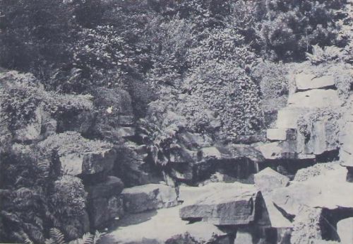
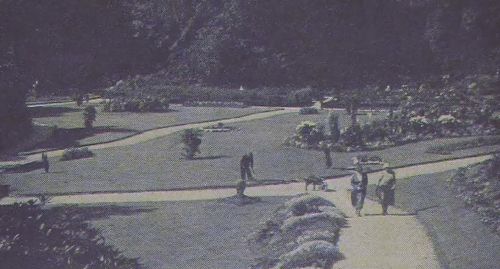
The Work of a Master.
Where is this work of a master? It is the Rockery at Howard Park, Glossop. No doubt you are going to say what we have said ourselves - “we had no idea that it was so lovely.”
This series has opened our eyes to the beauties of our own district. Last week's picture from Longden's Corner, for instance, created a furore and we heard more than one vow that they would turn and pause on Cemetery-road to drink in the glories of the view.
From time to time in these columns, have been sung the praises of Howard Park. It is worthy of all that has been sung about it, and more, for the landscape gardener who laid it was a master and an artist.
Age has mellowed and matured it, shorn it of its artificiality, with the result that it has now a fuller beauty than when it was created half-a-century ago.
Some people have never seen the Rockery. Hidden away down a slope in the path leading to the hospital, it is beautiful at all seasons of the year.
The proud owner of a new house, lucky enough to have a trickle of water running through his garden might, with profit, go to study its lay-out before he starts building a rockery.
How often has an otherwise lovely garden been spoiled by an unnatural lay-out. You'll not find the mistake here. The rockery represents a glen in miniature, with waterfall, bridge and pool, as natural as though it had been discovered in nature. Notice that all the rocks are laid on their beds as they occur and are not uptilted,
And now, if you have made a rockery in your back garden, go out and see how many mistakes you've made.
If we had as many pounds as times we have run down the little sloping turn to the rockery, we should be rich. More than halt of those occasions the same thought has occurred to us. What words would Lewis Carroll have put into the mouth of “Alice” had he sent her scampering down the little slope to discover this “Hidden Gem.” What would she have said as she sat on the rocks, swinging her legs over the pool and watching the little “Jack Sharps” dart here and there in its shallowness.
And the rockery echoes “I wonder.”
For more information about Howard Park see the article The creation of Howard Park.
A Bit of Old Glossop.
To most of us it is “Chris's Brew,” to a few “Woodhouse's Brow,” and to a very few it is Church-street South, Old Glossop.
That's its correct name, but only postal officials and “quaite naice” people know it by that name.
It may surprise you to know that the building now tenanted as a house and butcher's shop by Mr. A. C. Woodhouse is looked upon as the finest piece of Tudor architecture for miles around.
At one time it was tenanted by the bailiffs or stewards of the estate, and was obtained by Canon Fauvel who converted it into a school - so Daniel says in his life of Canon Fauvel.
Many inquiries have been made for the story to accompany the picture, and each of our local historians brings out a new one.
One idea is that the school of Canon Fauvel was the forerunner of the present Catholic School at Old Glossop, another that the school was never there at all, but in an out-building somewhere at the rear, and another-well, let's not bother about it, we can be “picturesque” and, interesting, without delving into pages of history, with the consequence that somebody writes to tell us we are all wrong.
We can say this is history. The house was the residence of the Wagstaffes, who were the bailiffs for the Duke of Norfolk, and also for Mr. Howard, who was at one time the owner of Glossop Dale Estate. In an advertisement of the first issue of the "Manchester Guardian," May 5th, 1821, there was a notice given by Matthew Ellison, the agent, and dated from Glossop Hall, April 16th, 1821, notifying the public that the letting by auction of the tolls from the toll gates or bars would be at the house of Mr. John Wagstaffe, of Glossop. And that is now the house and shop of Mr. A. C. Woodhouse. There is no foundation in fact for the statement that the Duke of Norfolk lived in the house. There now we must leave history.
Sufficient for us to say here that the picture will revive memories for those of us
Notice the door of death just showing round the gable end of the shop?
How many living creatures have walked through that door, through the “ginnel” to death?
For through that door they led “animals to the slaughter.”
In our younger days, Monday was one of the big days of the week, for did not Chris kill on Mondays, and didn't we go and pull on the rope, and wonder how many knocks with the poleaxe would be needed for “this big un.”
And what a scramble there was when Chris shouted “Bladder,” and threw it out amongst us.
It may seem rude that we should say “Chris.” We would never dream of saying “Mr. Woodhouse,” and to-day to Old Glossop he is still “Chris.”
Looking at the picture now, taken only a few weeks ago, the scene is just the same as it has been since we remember.
The “pointing” might seem a little new, but the buildings are there just the same.
And at the top of Chris's Brew there is still the “Bull,” and the “Wheatsheaf,” and at the bottom there is still the “Queen's,” (though the old “Hare and Hounds” has gone long since) and, in between, Is the Old Cross.
Yes, it is a bit of Old Glossop, and may it for years be spared from having its face spoiled with shops of futurist design and houses of red brick.
To some it may be a bit of Old Glossop, a sort of “Sleepy Hollow,” but to some (myself included) it is a bit of Old Glossop, the quietest, happiest place on the globe, because of childhood memories.
Philip Howard Road.
This picture will be particularly interesting for those who have not been in their native town for the last dozen years.
We can imagine exiles saying, "Why, this is the old Sandhole!"
Isn't there a transformation?
It seems hard even to realise that only a few years ago this beautiful boulevard was a huge hen-run and rubbish heap generally. And for the information of the exiles, there is a regular bus service across there now for the Whitfield district, and what a boon it is for those who live at “t top o' t' Cross.”
In the old days called the “Sandhole,” and sometimes “Pinchbelly Park,” its proper name is the Harehills Estate. It was given to the town in 1921 by the late Lord Howard in memory of his younger son, Captain the Hon. Philip Howard, who was killed, and the rest of the men of the town who made the supreme sacrifice.
As it is now, Philip Howard-road stands as a memorial to the persistency of Alderman R. Sellers. A constant advocate for its proper laying out, he was almost laughed at for his visions, but he stuck to his idea, and it was a happy day for him when he and Mrs. Sellers, as Mayor and Mayoress, jointly declared the road open in 1928, and we recall the martial airs the Glossop Old Band played as it headed a civic procession over the road for the first time.
Now the road is a “lung” for the people of the Whitfield side not able to get up to the town's parks, In summer, if you go any later than half-past nine, it's standing room only. Ladies never had a chance until the Corporation put “Ladies only” on several of the seats on the road.
Undoubtedly the road is worthy of the name of boulevard, and even photos taken in November reveal its beauty and majestic sweeping bend. From the road a fine view of the surrounding country can be obtained, above the industrial foreground.
Veterans of Philip Howard-road ask, “Where's that shelter?” They want one badly, but no generous benefactor has yet come forward to provide it. It's not too late.
We ourselves have two criticisms of this beauty spot - the Empire Marketing Board advertising board and the spare ground where the old theatre used to be. It's a blot on the landscape; less a blot since the tin hoardings have found another home on Glossop football ground.
Exiles will also marvel that the old Drill Hall and Fish Market have been superseded by the Municipal Buildings and the present Market Hall. It was really a splendid piece of transformation work, in which the late Alderman Bamforth greatly interested himself, and it
was during his Mayoralty that the new buildings were opened.
Strangers to the town are sometimes confused at the borough offices and officers not being in the Town Hall, but round at the back. Reminds one of the joke one of our local postmen is continually trotting out as we meet on Philip Howard-road, “I have been all over England, Scotland, Ireland, and Wales, and some places on the Continent,” he claims, “but I've never come across another place where the front door is at the back.”
When questioned, however, he admits that in all his travels, this district, even with its front door at the back, is as nice as any he's seen.
For more information about the Harehills area see the article Hare Hills, Sand Hole or Pinch-belly Park?.
Broadbottom Arches.
“Is this picturesque?”
We think it is, in its own particular way, and in any case because of their magnificence, Broadbottom Arches are entitled to recognition.
Picturesque is rather a relative term. It is a matter of opinion. For instance, within recent years a very fine “pub” has been built in Cockington, with thatched roof and everything to harmonise with the beautiful North Devon village with its famous forge. We look on the pub, with modern interior, as a picturesque addition to the village. A person who takes nothing stronger than water might think it was a blot on the village!
When we made our bow with this series we sad we hoped to bring you something interesting each week, and this we claim is an interesting picture.
Though popularly known as Broadbottom Arches, the real name is “Best Hill Viaduct.”
The foundation stone of this mighty structure was laid by Mr. John Chapman on Thursday, February 17th, 1842. On December 10th trains were run from Godley to Broadbottom and fourteen days later to the old station at Gamesley, so you see the viaduct had a Christmas Eve opening.
The road bridge in the picture, of course, is Best Hill, half of which belongs to Derbyshire County Council and half to Cheshire County Council.
A bigger and wider structure is needed here and the two authorities have talked about it for a long time, but it seems as far away as ever. That is in spite of announcements of the reconstruction work having been put in a so-many-years-plan.
Inches only are to spare when a bus is passing over, and it always fascinates us to watch the sweeping curve the drivers take to get over the bridge from the Charlesworth side.
This is after they have come down New York. This hill, a miniature Porlock in one section, has been the cause of many a cyclist finishing over the wall at the bottom, badly injured. And, if you're a motorist and can't change gears properly, don't attempt to climb New York.
From the Arches there is a beautiful view of the picturesque valley of Broadbottom. The scenery down the river, the Etherow, is very charming. Here is how an old writer described it :... “the river Etherow, flowing bright and tranquil through the valley, where the willows let fall their green tresses on her bosom.”
“Underneath the Arches, train rattling by above,” is a pleasant walk through Botany to Gamesley, where one can watch the wagons at the sidings travel along guided by an unseen hand and try to recapture in the mind's eye the quaintness and quiet aspect of Gamesley Fold as it was before those mechanical navvies tore at its very bowels to make room for these sidings.
“The Castle” in Winter Garb.
This picture of “The Castle” in winter garb should prove an inspiration to poets. “Upon the Castle high King Sol hath cast his win'try eye.” - That will be sufficient. - Editor.
The “Castle” is part of Mouslow, the site of one of Glossop's traditionary castles. Mouslow hill is completely surrounded by a trench, now used as a path, and it appears to be an ancient British or Saxon castle.
This picture is taken from the Park-road side, from in front of Hill Top Farm to be exact.
As the Romans settled in Britain, their camps lost their original form and became castles. These, on the Roman departure from Britain, became British castles, the homes of chieftains of the Britons and the scenes of conflict with the Saxon invaders.
Archaeologists have proved that Melandra was at one time a Roman encampment or castle, and doubtless Mouslow became a stronghold of the Britons or Saxons or even perhaps of the Romans though no coins or stones have been found there as at Melandra.
Here is a legend we have come across about the two.
In ancient times a castle stood at Melandra, occupied by a great prince. “Wholley” (Woolley Bridge) opposite, was a city then. On Mouslow stood another castle, occupied by another prince. These two were at constant war until it was ended at a great battle on the plain before Mouslow. The prince of Mouslow, called Almand, was slain, just as victory was inclining to his army.
The ancient chronicler of this incident writes: “... the rays of the sun setting in golden glory behind the Mottram hill, gilding the helm and breastplate of the dying warrior.”
The name Almand is Saxon, meaning “All Peace.” Near Huddersfield is a place called Almandbury Castle, which antiquarians suppose to have some connection with the hero of this legend.
This part of Mouslow got its name of the “Castle” from Mr. Bernard Howard, the then owner of Glossop, about 1800, when he planted the hill with fir and other trees.
Now Mouslow produces some very fine stone from its quarry, from where frequent sounds of blasting operations resound through the two dales. More modern still is the brickworks erected on the Dinting side of Mouslow. These cropped up in the news again a few weeks ago when Councillor E. Greenwood sold them to a Yorkshire company.
Round the Castle, round the Ashes or round Mouslow or through the fields from Higher Dinting - all these bring us round the bottom of this ancient camp site - are much frequented and pleasant walks. But if you tackle anyone of them at this time of the year, you will certainly find a winter beauty, though when you get back again on the roads you will not be an advertisement for any kind of boot polish.
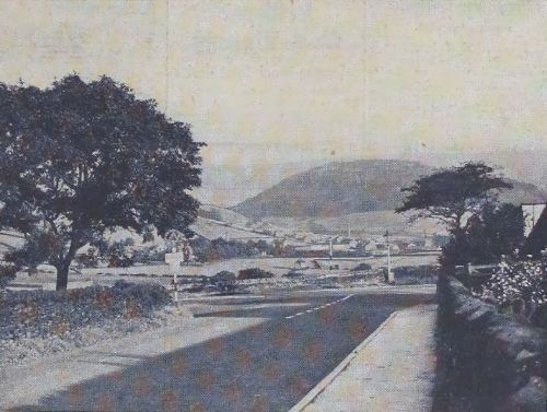
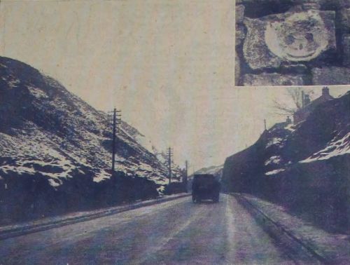
The Deep Cutting.
Stage coach drivers and riders who once passed through this then lonely cutting would stand and stare if they could return and see the constant stream of “horseless carts” which go nowadays through the Cutting, from the modern stream-line to the old tourer, from the latest six-wheeler commercial to the type which looks as if it will drop “from-together” any minute.
It was in 1826 that the Cutting was made for the Manchester and Saltersbrook Turnpike Trust.
Having it always on our doorstep, familiarity breeds contempt, but we often wish we could experience the thrill a stranger to the district must experience when he comes through the Cutting for the first time.
Let us say he is coming from Manchester. All the way he is hemmed in by industrialism. What little bit of green he may pass on the road is put there by man, not nature. Conditions improve a little coming up from Stalybridge, and then as he emerges from the Cutting he sees before him the magnificent beauty of our Longdendale and Glossopdale, with Mottram Parish Church conspicuous in the foreground.
Drink in this view at your next opportunity, and see if it does not compare favourably with views you have raved about on your holidays.
But don't make the opportunity these days. Wait until the weather is warmer. The winter blast seems colder in Mottram Cutting than in most places in our two dales.
In the Cutting you will find there is a stone with the impression of a frog on it (See inset on photograph). Popularly, it is said that when the Cutting was being made a live frog was
found imprisoned in the stone when it was split asunder. We would rather think that it was just a freak of nature.
Off the old road above the Cutting can be seen the Roe Cross stone about which there is rather a pretty legend.
Here it is. Ro, a young knight of Staley Hall, left his fair domain and his newly-wedded wife to wend, like many others, to the Crusaders in the train of Richard Coeur de Lion. Before parting, with many tears, they broke her wedding ring, each retaining a half as a pledge of mutual fidelity. Fighting in Palestine, he was taken prisoner and, after years of captivity, he secured his liberty and visited the Holy Places before his return home. In Jerusalem he had a dream, boding ill to his wife and home. Awake, his dream troubled him greatly and, after walking by the side of the river, he sat down in the shade and fell into a slumber. On awakening, he found himself lying on a grassy bent, beside a large stone, the cool evening breezes were fanning his face and the birds were singing sweetly around. He knew at once he was not under the burning sky of Palestine and, on looking round, he saw he was in the neighbourhood of his home.
At once he made for home, knocked and asked the maidservant who opened the door if he might speak to her mistress. She told him he could not. Tidings had reached them that her mistress's husband, Ro (old vernacular for Ralph) was slain in the Crusades, and her friends were forcing her to wed again on the morrow, and she was so distraught with grief that she wished to see no one.
The maid, however, invited him into the hall for refreshment. Having drunk the wine, he dropped the broken ring into the cup and asked the maid to take it to her mistress.
On seeing the ring, the mistress thought the man must have brought some message from her husband. With his altered appearance and his clothes she did not at first recognise him, but when he revealed himself the joy of both can well be imagined.
And after that the accent is on the legend.
The stone is supposed to be the one under which he found himself, and Roe Cross gets its name from the wayside cross they were supposed to have erected in memory of his return.
In the “Staley Chapel” at Mottram the ancient monument of a knight and his lady is generally understood to be to the memory of Sir Ralph and Lady de Staveleigh, of Staley Hall, who, in fact, did exist.
Carr Meadow.
Again this week we have to excuse ourselves for stepping over the boundary lines of our picturesque map, but if this picture is received as well as the one last week apologies are not necessary.
We recall a story in which the hero was nick-named “Two-to-one So-and-so,” because of his habit of laying those odds on anything - “two-to-one this,” “two-to-one that,” and so on.
We can adopt his saying and lay you those odds that you don't know where this picture is. We purposely left the name of the district out of the heading. It's Carr Meadow, Hayfield, found at the bottom of the steep Hollingworth Head. And though Carr Meadow is as familiar to us as our own back garden, we failed to recognise the picture at first because of the new angle from which it in taken. But how, you ask, can it fit in with our title.
In one ancient book the description of Glossop is: “Glossop is in the hundred of the High Peak and the County of Derby, and is the last of the high chain of mountains called The High Peak of Derbyshire. It comprises the hamlets of Hadfield, Padfield, Whitfield, Chunal, Simmondley, Gamesley, Ludworth and Dinting; the chapelries Hayfleld (mark that), Chapel-en-le-Frith and Mellor, and the liberty of Chinley.”
The author, in another reference, says “Glossop, in the good old Saxon times of St. Edward the Confessor, belonged to Levine. In the Doomsday Book it belongs the Crown as part of Longdendale.” It was granted, along with other lands in the Peak of Derbyshire.
by William the Conqueror, to William Peveril, his natural son, whose memory is perpetuated by, the old ruined tower of limestone, perched like an eagle on a rock on the top of the famous Peak Cavern.”
He gives Glover's “Derbyshire” as his authority for this statement.
So though it doesn't apply now, Hayfield was once both in Glossop and Longdendale.
Carr Meadow is well known to Peak ramblers as they branch off the road to join the path which leads by William Clough to the Snake Inn path is clearly seen in the picture and as we go down the hill we can see the path winding up the hill until it disappears from sight by the rim of a wood.
On a summer's evening, as we sat over coffee and cigarettes in the cafe's pleasant garden, seen in the picture half way up Hollingworth Head, we have watched ramblers pass who have taken the Snake side first and they have looked footsore and weary as they trudged up the hill, making for Glossop station.
For motorists, Carr Meadow corner is a tricky piece of road either way. There are a couple of narrow turnings in the hill.
In one of the cluster of Carr Meadow's picturesque cottages, whose old-world gardens are a veritable glory in the summer, lives friend Lot Pickford.
To lovers of the Peak country - and who of us is not? - one of the cottages makes a special appeal, as it was where Mrs. Humphry Ward stayed when writing “The History of David Grieve,” a novel which, more than any other, depicts the gloomy spirit of the “Scout,” the eeriness of the Mermaid's Pool, and the savage character of the Downfall Gorge.
It is said that whilst the authoress was engaged on this book, she had occasion to go to Manchester, leaving her manuscript lying about. Her landlady, thinking this an opportunity to give the room a good cleaning out, collected all the loose papers on the tables and chairs and consigned them to the fire. Picture the consternation of the authoress on her return to find her precious manuscript in ashes. She must have set to and re-wrote it, as we have the book.
At the cottage next to the end there lived at one time, Old Sarah, a reputed witch.
Rose Garden, Manor Park.
No apologies are needed for this week's picture, for we are right back in our territory. It is
beautiful, isn't it? And it would be rather an insult to your intelligence to inform you that it wasn't taken this week.
There's too much of the breath, action, and dresses of summer about it for January.
Manor Park's is not a rose garden in name only.
In summer it is a rose garden. There is the Garden of Remembrance of the local branch of the British Legion which is planted with hundreds of red roses, purchased by public subscription. More red rose trees were placed on the opposite side. In addition to this mass of red there are the other beautifully-coloured roses up and down the gardens, besides the other various flowers, not forgetting the lupins.
In summer the rose garden is lovely. People have passed many hours there, either reading, crocheting, knitting, or basking in the sunshine.
For ourselves, we've done none of these things, though we've strolled through the garden, filled with admiration for its beauty. Reason is that “we can't abide,” as our colloquialism goes, those gnats which have their home in the rose garden, and, indeed, throughout Manor Park.
One of the high spots of the year in the town's events is the British Legion's annual festival or remembrance in the rose garden.
Twenty years ago none of us ever thought we should be strolling through the hall grounds at will, much less see people playing tennis and bowls within their walls. Manor Park, as it was called on being acquired by the Corporation, is now the play place of Glossopians.
For ourselves it has not reached Utopia. We look forward to the time when the wall along Manor Park-road is demolished and replaced by railings so that we can admire the park as we go along.
Alderman (then councillor) J. E. Buckley had the proud honour of formally opening the park when he was Mayor in 1927.
A tablet at the entrance to the park is almost a little history book in itself.
Its inscription reads: “These grounds, formerly the seat of Lord Howard of Glossop (the Lord of the Manor), were portions of the Manor of Glossop, at one time part of the royal demesne, within the lordship of Longdendale. At the time of the Doomsday Survey the manor was granted by William the Conqueror to William Peveril, but on the attainder of
his grandson it reverted to the crown. In the year 1157 King Henry II gave the manor to the Cistercian Abbey of Basingwerke, in the diocese of St. Asaph. On the dissolution of the monasteries King Henry VIII gave it to Francis Talbot, fifth Earl of Shrewsbury. The manor passed to the Howard family through one of the co-heiresses of Gilbert, Earl of Shrewsbury, who died in 1616. On 29th April, 1927, the grounds were acquired by the Mayor, Aldermen and Burgesses of the borough of Glossop for use as public recreation grounds, and were formally opened by the Mayor (Councillor Joseph Edwin Buckley, J.P.)
on the 17th day of September of that year.”
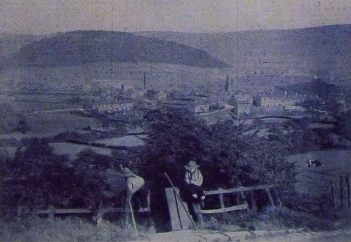
Bankswood, Hadfield.
Here is a view of Bankswood, Hadfleld, or, as it was formerly called, “The Castle.”
Always partial to open spaces, we like them best when they are on a hill. We like to get to the highest path at Bankswood, under the trees of “The Castle” wood, and admire the extensive view of Longdendale.
These paths which have been cut at Bankswood, always strike us as the best improvement made there up to the present. There are the paddling pool and roundabouts and the tennis courts which satisfy other desires, and, of course, charming flower beds in summer and autumn.
Officially, Bankswood was purchased by the Corporation in 1926.
Unofficially, the story goes that Bankswood was obtained for nothing. Becoming the property of Mr. J. Todd when he purchased the Glossop Hall Estate, he sold it to the late Mr. R. Wilson. Mr. S. T. Ashton, then chairman of the local Finance Committee, interviewed Mr. Todd, asking him to throw in Bankswood with the purchase money for Glossop Hall and grounds. Mr. Todd regretted that he could not do so as he had already sold it to Mr. Wilson. Mr. Ashton pleaded and argued, and ultimately Mr. Todd bought the land back from Mr. Wilson and put it in with the Glossop Hall and grounds purchase money.
Bankswood itself was not officially opened like Manor Park, but it was a great day for Hadfield when the slipper baths at Station-road, and the tennis courts at Bankswood, were opened on a beautiful summer day. Mrs. H. L. Roebuck and Mrs. R. J. Boak, you may remember, had the first game of tennis.
There was big opposition when the railway company announced their intention of closing the level crossing which had always been used as a short cut. Members and officials of the Council went to London to interview high railway officials, but the company stuck to their decision and would not put a footbridge across.
It was wise to close the crossing in view of the increase in pedestrian traffic since Bankswood had become such a rendezvous, but it was a distinct inconvenience, and still is, that a footbridge was not erected.
A missing link to Bankswood's completeness is a pavilion. How many wordy wars have there been in Glossop Town Council over the need for a pavilion. Undoubtedly, a pavilion is required and, now that through the thoughtfulness of the late Mr. T. Firth, a sum of money has been left for the provision of a “shelter” at Bankswood, we can expect something to be done within the next twelve months.
For more information about Bankswood see the article Bankswood - Hadfield's Park..
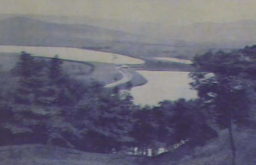
Tintwistle From the “Courting Tunnel”.
The “Courting tunnel” is on the Derbyshire side of Bottoms Reservoir, shown in the picture, and is no strange place to the Hadfield Romeos and Juliets. The walk, by which it is reached, is not the monopoly of courters, however. It is enjoyed by everyone, and, no wonder, for it is very pleasant and the air from the Longdendale reservoirs has an
invigorating tang about it.
The photograph gives an unusual angle on “Tinsel.” Christ Church is easily seen and also the Independent Church and the Manchester Corporation offices. It is a comprehensive view of the upper part of Tintwistle.
Sometimes I feel we don't appreciate as we ought the beauty of the Longdendale Valley and its chain of reservoirs.
Many times we have heard fellow passengers in a railway carriage, going through the Valley for the first time, marvel at its beauty. On foot or by car, the journey up to Woodhead is pleasant, either on the Cheshire or the Derbyshire side. Personally, we prefer the Derbyshire side, which enables us to see up the whole length of the water from the last turn before the straight, down to Torside Crossings.
The Longdendale Waterworks of the Manchester Corporation were the first of their kind in the country. There was little experience of which to take advantage, with the result that a considerable amount of trouble, arising from such causes as imperfect foundations and floods, had to be faced.
Manchester Corporation purchased the gathering grounds in 1847.
Longdendale Valley forms part of the boundary of the two counties of Cheshire and Derbyshire. The gathering ground rises from 500 to 1,900 feet above sea level and has an average rainfall of about 45 inches. Drainage of about 19,300 acres of the westerly slopes
of the southern end of the Pennine Chain flows into the reservoirs, giving a supply
of about 22,000,000 gallons a day.
At present work is progressing on the whole chain, which will increase the storage capacity of each.
From Longdendale reservoirs Manchester gets a flow of the best and purest water and for the privilege pays more than half of the rate at Tintwistle, besides paying to Glossop Corporation for the land on the Derbyshire side.
And for the ordinary ratepayer round here, Manchester has provided a lovely valley with many a picturesque walk and several prolific pools for anglers.
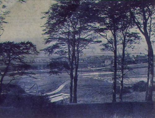
An Unusual Angle from the Arches.
How about this for an unusual angle? This picture is taken from a train going over Dinting Arches.
From the arches, as we have said before in this series, can be obtained a magnificent view of Glossopdale and Longdendale.
Prominent are the Dinting reservoirs, which provide water for the Dinting Printworks.
At present extensive structural alterations are being made at the works.
Another big change is shortly to take place there, Mr. G. W. Taylor resigning from the position of manager, to be succeeded by Mr. H. E. Farrar.
There is something at Dinting Printworks which is a town's institution – the “buzzer.” We have got accustomed to setting our watches and clocks by the Dinting “buzzer,” which can be heard all over the two valleys.
Round the reservoirs is a much favoured walk by the operatives at the Dinting Printworks during the dinner hour in the summer. A common sight is to see some playing cricket, others football, and others lying on the banks, smoking the dinner hour away. A less common sight, because only now and again have we weather warm enough to do it, employees and schoolboys have a swim there.
No mention of the Dinting reservoirs would be complete without reference to the stately swans who have made their home there.
Skating has also been enjoyed on these reservoirs, or to give them their better known name of lodges, and, in this direction, they will always be remembered as the scene of a double tragedy and a heroic act.
Two years ago Charles Hand lost his life in attempting to rescue 11-years-old Donald Wragg, who was also drowned. Charlie's heroic act received the town's recognition, and an award from the Carnegie Trust, which was presented to his mother by the then Mayor (Councillor Beckmann).
Not very clear, certainly, in the picture, but Longdendale is in the background, and, in the foreground, to exiles from the town for many years will be the strange sight of the “white line” instead of the “Plough loop” of tramlines which they remember. It could be said here for their benefit that there is no indication now that there was ever a tram track between Old Glossop and Hadfield, a fine macadam road bridging the distance.
Here's a bit of advice to motorists, motor cyclists, and cyclists. You can just see the Plough Brow or, to give it its proper name, Nursery Brow. Halt there before you come into the main road, or a police officer will “book” you if he sees you. Take it from us, there is a halt sign in Nursery Brow.
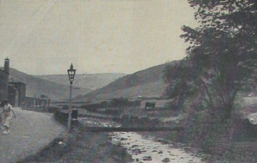
Black Clough, Woodhead.
The geography is correct. It's Woodhead, not Wales, although it's not unlike the scenery one gets around Bettws-y-Coed.
During the summer, thousands of motorists park their cars about a quarter of a mile beyond Woodhead Station to admire the beautiful scenery of this Clough.
Unfortunately, they have to admire its beauty from afar. The public are not allowed access up the clough.
Only a comparatively short distance further into the hills the stream you see in the picture rises from the earth. It is the beginning of the River Etherow, which eventually, with other tributaries, becomes the great shipping river, the Mersey.
Next time, then, you are waiting for the “Ben-My-Chree,” or the “Mona's Isle” of the Isle of Man Steam Packet Co. to take you across to that charming little island, you can have pride in the thought that some of the water has come from this particular beauty spot in your area.
On the right of the picture is the shooter's cabin, known as the Black Cabin where many a fine bag of grouse has come to rest, and where, too, many a pint of ale has been quaffed by the beaters, to whom this picture will be very familiar.
Three years ago a party of Yorkshire ramblers were lost about a mile higher up the moors. One of the party managed to stagger and crawl over the boulders and rough ground in the dark ness to inform the cottagers at Woodhead on the Sunday night. Gamekeepers and others searched throughout the night and came across the party about seven o'clock on the following morning.
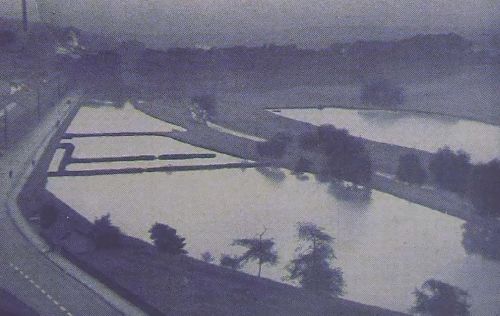
The Hatcheries, Arnfield.
The praises of the beauty of she chain of Manchester Corporation reservoirs in the Woodhead Valley are often sing, and we are apt to forget the beauty there is in the Arnfield vicinity.
In the foreground of this picture is the Hollingworth Reservoir and Arnfield is in the background. The photograph gives an idea of the magnificent view you can obtain. The Castle and The Nab stand out prominently.
At Arnfield there is the hatchery where last season tens of thousands of fish were hatched.
Reservoir Keeper W. Miller takes a keen interest in this breeding business. He puts the spawn in the hatchery and later the fry are transferred to troughs of running spring water. When about twelve mouths old they are distributed amongst the Longdendale reservoirs. In a new place at Rhodes Wood the fish can be kept another twelve months before they are liberated.
“Summer is a-cumin,” and if you have never been round Arnfield, remedy your mistake and go this summer. For through Arnfield itself however, permission - which is sometimes given, would have to be obtained from the Manchester Corporation.
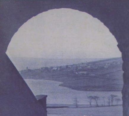
Old Glossop from Woodhead Road.
Trying to be unbiased, we are of the opinion that this is one of the finest views in this series. In “Round and About” last week “Pilgrim” was singing the praises of the other side of Old Glossop. Perhaps he will admire this part. He will not be the first who had done so.
Many times have we seen motors stop at Dan Longden's corner to allow passengers to admire the surrounding view.
Shire Hill forms a splendid background and the steeple of the old Parish Church a fine centre-piece for the picture.
Just think for a moment of the Parish Church! It was in existence before the Domesday Survey was made in 1086. There is no documentary or other evidence to show or prove at what particular period it was built. Anglo-Saxon nobles lived in Glossop, however, and it is quite probable that a church was on the present site at a very early period.
A list of vicars of Glossop can be obtained from 1321, and the registers of the church date back to 1620.
Scouts on the photograph are at the entrance to Back Sitch, a much used short cut into Old Glossop.
Though we have used the short cut many, many, times, we have never been able to discover how the name was coined.
Probably it comes from the Anglo-Saxon word “sith,” which means a path, and through the years the “c” has been inserted by bad pronunciation or for ease. Anyhow, the name now is undoubtedly “Back Sitch.”
Had the Scout been an Old Glossopian he would not be sitting on the fence. He would be leaning against the stone, which slants at an angle, and provides a restful “leaner” after the pull up Back Sitch.
In the left of the picture can be picked out the top of Hope-street – Roughtown if you like - and memories crowd on one of the old Greyhound Inn and the teams of horses which used to mount “Charley Loan” for stone from the Low Quarry. They were he-men in those days.
There is also “Sammy's” Mill, whose old water-wheel, though we have reached the age when we should be above such things, still fascinates us, and when we pass that way we always glue one eye to that little hole in the window, as we used to do, well, was it ten, twenty, thirty, forty years ago?
A Peep into the Past.
We have dipped into the archives for this picture. For the older ones it will bring back happy memories; to the younger generation it will be news that swans swam on the lake at Howard Park.
The swans have done what old soldiers are reputed to do-they have faded away.
This photograph shows the lake in Howard Park before the swans had quit the scene (writes “H.R.B.”), and will recall to many Glossopians a once-familiar setting.
The island is now a little overgrown, and has become an ideal nesting ground for wild fowl, who now form the lake's only “floating” " population.
What a lovely composition this is! How clear the monument - commemorating one of the founders of the park - rises within the grassy glade, which falls gently to the water's edge!
To the right of the picture, a second glade shows where the band used to discourse sweet music on Sunday afternoons, whilst listeners sat amid sylvan surroundings, and lovers sauntered by velvety turf and glowing flower bed.
At the head of the glade we catch a peep of Wood's Hospital, where the work of healing the sick goes on day and night.
How well we remember one year, when the rhododendron bushes fringing the lake, were a blaze of gorgeous bloom from end to end!
At all seasons this view is one of outstanding beauty, each season – spring, summer, autumn and winter - brings its own garment to drape the borders of the mere.
How often have we stood to admire this scene from the road on moonlight nights! The monument standing out in virgin purity - the still air, the silvery ripples across the lake, and the trickling and lapping of the waters, more an echo than a sound. Surely, we who live in this locality are fortunate that nature and art have combined to give us so beautiful a spot.
A View from Gamesley Bridge.
We know that this picture might not come under the heading of “picturesque,” but who can deny it is interesting?
It is included principally for our overseas readers and you'd be surprised if you saw the number of “Chronicle and Advertisers” which are despatched from our offices each week. Add to those, the numbers which are sent by relatives to those who have left their native town for lands far beyond the sea.
For them the picture will be of tremendous interest. They will see that the face of the view from Gamesley Bridge has been entirely changed.
It was a big engineering feat to make these sidings, properly known as a marshalling yard which relieves congestion at the Godley Sidings.
Farms and land had to be bought and the mechanical “navvy” tore into the sides of Gamesley Fold and on the Glossop side of the bridge to make room for the tracks.
Gamesley Bridge itself was widened and a new bridge set up at Botany whilst a new footpath from the Charlesworth side into Broadbottom was made.
Operated by what is known as the gravitation system, the yard is one of the most modern on the railway. It was opened, after about three years work, in October, 1935.
All the marshalling is done from the control box seen in the foreground of the picture, though, of course, men are also on duty in the yard.
On the Dinting side of the bridge can be found a similar sight to that shown.
It is rather interesting to see the sidings at night when the specially shaded lamps make it rather eerie looking.
Wood's Hospital.
This photograph is another reminder that Glossop is fortunate in her past sons and daughters. The situation is Howard Park, and the building Wood's Hospital.
It was at a special meeting of the Glossop Town Council, on November 4th, 1886, that a communication from Mr. Daniel Wood, of Derbyshire Level – one of the proprietors of Howard Town Mills - was received, in which he stated that he was prepared to build a hospital at the cost of Ł5,000, and endow it with Ł20,000.
Since the time of its inception, what a useful institution it has proved to be! This is not the place to recapitulate its services. Its most valued record lies in grateful hearts and restored bodies.
How beautiful its surroundings surrounded by parkland and pure air; its silence broken only by the song of the birds and the call of the wind.
This photograph will recall to many the anxious hours spent there - the fear - the pain - the recovery.
No Institution In the town has called forth more effort to meet its growing demands.
Voluntary resources have been taxed repeatedly for its maintenance, and the need grows.
As the readers look upon this picture - especially those in far away Canada and Australia - telling them of past generosity, reminding them of the service which is unending, they may be persuaded (writes H.R.B.) to make a small contribution to what can be rightly termed, their own hospital.
Lately, in the Glossop Council Chamber, many words have been uttered about the finances of Wood's Hospital, and there is a divergence of opinion as to whether it should remain as a voluntary Institution or be supported out of the rates.
We are sanguine enough to think that the affair will soon be satisfactorily settled.
Young 'uns will have eyes for only one thing in the picture - the Fountain, which is the Mecca for all young people who go to Howard Park.
Many times we have seen lads dressed “in their Sunday best” wet through after a particularly hectic time round the Fountain and always we have thought, “Walt till you get home, lad, you're for it”.
For more information about Wood's Hospital see the article A Brief History of Woods' Hospital..
The Nab.
This series would be incomplete without a photo of The Nab. Glossop and the Nab – Whiteley Nab is its full name - are almost synonymous. It towers above the town like a huge sentinel, but this picture is taken from a fresh angle and shows what might be called the back of the Nab.
The little hamlet of Simmondley is shown sheltering under its shadow. There is a great movement going on at present to beautify this lovely little place. People, however, are asking whether Simmondley is really being beautified. They are of the opinion that this “beauty-culture” of the village is taking away its old-world appearance and atmosphere which are its greatest charms.
Exiles will wonder what the houses are in the foreground. Those are Council houses built in Simmondley-lane, and the time is rapidly approaching when all the lane right up to the village will have houses on each side and bang goes another country walk.
It is a sad commentary on our so-called enlightened times that A.R.P. form a big topic of conversation. Many times recently we have heard it said that Glossop could easily make air-raid shelters by excavating in the side of the Nab.
The Nab is well-patronised during the summer. A walk up the Nab and an hour lying on its grassy slopes admiring the glorious view is a pleasant Sunday afternoon occupation.
North edge of The Nab is 1,000 feet above sea level. If you think you are in need of slimming, don't bother to go on grapefruit or a diet. Just climb The Nab every morning before breakfast for a month and your figure will soon become slim.
Mossy Lea.
With plans almost completed for the Easter break, this typical scene of Mossy Lea is very appropriate because during this holiday scores of ramblers will turn in at The Wharf and up Mossy Lea en route for Doctor's Gate.
The less energetic of us will keep to the right at Mossy Lea Bridge and complete the circular walk to Sheffield-road.
Round Mossy Lea (what an endearing name!) is still a favourite after-Sunday school walk as it was in our younger days.
The brook can be crossed more elegantly and safely at Thorpe Bonk (as we used to call it) than it could be in our younger days. A plank bridge has been erected and we used to step gingerly from boulder to boulder, and more than once have had a wetting when a stone “tipped up.” There used to be a flood gate here, and we have seen many a sheep lying there, swept down by the brook from the moors above.
Farther on round Mossy Lea is the gamekeeper's old cottage, which we had occasion to watch in our school-days (writes H.R.B) as we wriggled through the heather on our stomachs, on the way to a cave among the crags above. Isn't this cave now blocked up with huge boulders?
There is the weir of crystal water on the left, where we used to look for trout, and the shady copse by the water side is well remembered. Although our errand was bird-nesting, the memory that remains is of tender lavender mayflowers peeping through the lush grass.
In a previous story in this series we told you of the legend of Doctor's Gate, in which Old Nick figured prominently. Mossy Lea boasts a legend also. It concerns a schoolmaster who dabbled in witchcraft and the black art. The Mossy Lea pedagogue, we are told, was in urgent need of an important tome of mystic lore and despatched two of his pupils to Staffordshire to bring it, enjoining them on no account to open it. But, curiosity overcame them as they neared home to see what this precious book contained. They undid the
clasp and lifted the cover. Immediately a hurricane arose, tearing up trees, and spreading devastation along its course. The schoolmaster, noticing the storm, divined the cause, and by means of a magic spell caused the winds to cease.
A few years ago the Glossop Trades Council endeavoured to get the road round Mossy Lea repaired, and there was considerable correspondence with the Town Council on the matter.
The road could certainly do with repairing, but do we want it repaired? Just fancy, a macadam road or just an ordinary common or garden level road round Mossy Lea! There would be less demand for boot polish after the walk, but more than half the pleasure would
be taken away. Mossy Lea must retain its rural aspects and its rugged and muddy road.
Up the Valley.
Railway travellers from London way, emerging from Woodhead Tunnel into Longdendale Valley are always impressed by the sombre grandeur of this mountain corridor, especially
should the hour be approaching sunset, when the gloom blends with the black rugged escarpments that bound it, with the sepia of peat and boulder, and the low tones of
heather, and while the waters of the chain of Manchester reservoirs add their silvery ribbons of light.
The photograph, showing the top end of the Rhodeswood Reservoir, near Tor Side Crossing, is a typical Longdendale scene. It will be familiar to those who know the path from Padfield alongside the reservoirs to Tor Side.
On the right, Tor Side Naze rises behind Long Gutter Edge and fringes one of the wildest and least traversed stretches of moorland in the country, which must have witnessed many an unrecorded human tragedy in the past. A few years ago a youth met his death near Wildboar Clough, behind Tor Side Naze, when on a walk between Marsden and Edale, and in February of 1935, five ramblers spent a cold night on these moors, huddled together in Black Clough, but a few miles from the above scene.
On the moors away to the left, is the spot, where a few winters ago, three girl hikers spent three nights, and were found on the fourth day in an exhausted condition - a record of human endurance on the Pennine Moors.
Nowadays there is considerable activity up the valley, where the Manchester Corporation are carrying out big improvements at each of their chain of reservoirs. Dry spells take their toll on these reservoirs in spite of the huge gathering grounds they have, and the effect of the present dry spell is easily evident.
Railway passengers are not the only ones who glory at the beauty and air of this valley. Motorists run out from neighbouring towns just as far as the tunnel mouth and back either by the Derbyshire side or the Cheshire side, just for a sniff of the smoke-free air of Woodhead, and ramblers, too, enjoy the wide sweeps of the moors.
There are no more ardent lovers of Woodhead than the Manchester “Terriers” who come up in batches during the summer for week-end training at the Crowden Rifle Range.
Changing Glossop.
It would be quite possible for an old Glossopian, on re-visiting his native Glossop, after a lapse of but a few years, having to rub his eyes, and look again, when visiting certain
parts of the town. Such a spot is the one shown in the photograph, at the corner of Spire Hollin and North-road.
He would remember the spot as one that could not change, associated with a fixed institution of the town – the Howard Estate offices and grounds. Now the walls have been removed, the trees felled, and the boundary pushed back. He would see in their stead newly-built houses with front gardens, giving a totally different aspect to the corner.
These houses, standing out in their newness, with their gardens, (of which the photograph shows but two blocks) produce a sense of spaciousness, which such a change would warrant. The gardens, in spite of newly-turned soil and turf, are showing signs of attention and care. Efforts are being made to make the surroundings pleasant, and conformable to a general idea, even to design and colouring of window curtains. In fact, the ensemble shows a house-proud set of occupiers.
Continuing along Spire Hollin, something of the old quieter and more subdued atmosphere remains. The Estate Offices have been converted into dwelling-houses, and in the process of change to meet the needs of modern dwellings, they have lost something of their solidity and uniformity, but the walls bounding the road have remained unchanged.
To some of us of an older generation (writes H.R.B.), this retiring lanelike quality, with its repose and touch of gloom, gives something which glaring light and space do not give.
Continuing to the end of Spire Hollin, where the corner opposite Victoria Hall has been rounded and set back, and a dry-wall built, we are pleased to note that a group of fine trees have been loft standing. We are glad of this opportunity to comment on the wisdom of this. The surroundings of public buildings, especially those of an educational character, churches, and so on, should be of such a nature as to induce reflection, and calm. Shady trees make a contribution to this end.
The neighbourhood of Spire Hollin catches something from the past. Buildings and even walls, if substantial and good, gain something as they mature, and everything that Lord Howard built will stand this test of time.
Throughout the country, houses are being built in their tens of thousands, but they are not homes; many of the cottages they have replaced are homes. Before a house becomes a home, there must grow around it a mantle of human association, which gives to it a subtle quality, sensed more than understood, which reacts on the people who live there - the associations of childhood, sorrow, joy, love, struggle, day-dreams, all these experiences give to the house a spiritual quality, and it becomes a home in the highest sense. This is why well-meant slum clearance schemes, when carried out by those without a deep and sympathetic understanding of life, become heart-breaking tragedies, but time marches on.
Farewell.
On forty-one occasions, almost consecutive, we have stopped the roar of Glossop and Longdendale traffic to bring you something interesting and picturesque. When we made our bow on July 9th we said, like the announcer for “In Town To-night,” “we hope to bring
you something interesting each week.”
Perhaps it hasn't always been picturesque, but it's always been interesting, and we're happy in the knowledge that more than one reader has cut out this photo and story each week to save for future days.
Now the time has come to say farewell. To keep up the B.B.C. idea; you remember when they stopped their “In Town To-night” feature, their explanation was that they wanted it to cease, for a time at any rate, when it was enjoying popularity, and not when its interest had begun to fade. That is how we want to do, or to express it in the real Glossop and Longdendale manner - “We're gerrin' out while t' gooin's good.”
Our last pictures are a general view of Glossop (taken from the Heath) and one of the main street.
Glossop! Peculiar name, y'know. And who of us hasn't called it more peculiar names? It's this and it's that; it's so-and-so and so-and-so, but it makes all the difference when we realise that Glossop is another way of spelling “home.”
Things are just a little difficult now, but we shall pull through all right and the sun will feel all the warmer when it does break through the clouds of our industrial sky.
Glossop has not changed much with the passage of years when you look at it from the heights which surround it on all sides. The top picture will convince exiles of that, but it's when you walk in Glossop itself that you find such changes as we showed you and talked about last week. The bottom picture will look rather strange to some exiles. Many of them have never seen High-street West since tram lines ran down its centre.
It is to those exiles from Glossop and Longdendale that we think this series has made the most appeal; it has brought them little glimpses of home, perchance reminded them of a childish adventure, or a youthful episode. But we mustn't get too sentimental!
Giving place to none in our love and appreciation of the beauties of this area, the series has helped to increase our affection. And from the remarks heard in those several places where the World and his Wife do express their opinions, it has revealed to many of the residents in the area the beauties on their very door-steps - beauties which previously (from their observations) they either never realised or to which they shut their eyes. Even an inanimate prophet is not recognised in its own country. Of course, the same places transplanted to Devon, Scotland or the Continent would be beautiful.
Yes, the series has done away with a lot of that feeling and taught appreciation.
And, if to all who have read it, have derived as much pleasure as we who have been doing it, well then, the effort has been worth while and “a good time has been had by all.”
A.E.
Return to GJH.me Home Page, Return to Glossop Area Local Histories index.
Last updated: 13 November 2025