Churn Milk Hall at the Corner of Hadfield Place and James Street.
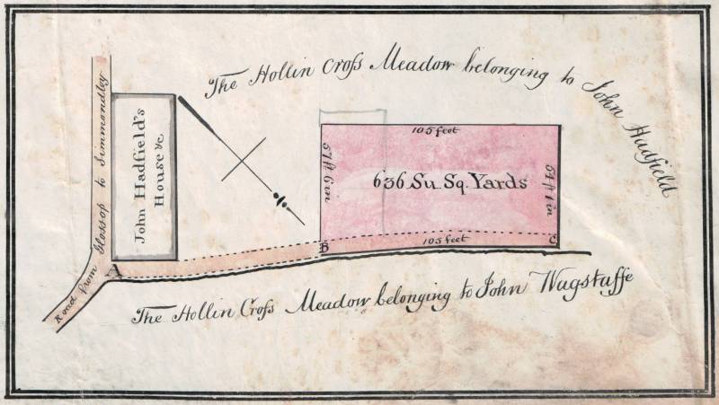
The plan above is taken from an indenture dated 3 August 1833 by which John Hadfield leased the land coloured pink to William Hurst, a cotton dresser of Whitfield, for 999 years for the purpose of building dwelling houses thereon. The land's south east border was 57ft 6in, its south west border was 105 feet and its north west border was 54ft 1in. In total, the plot comprised 636 superficial square yards.
The “Road from Glossop to Simmondley” became James Street, leading from Victoria Street (which was the turnpike road) to Hollincross Lane. The new road from A to C was to be built (first 12 yards from A by John Hadfield and the rest by William Hurst), with a gate at C, to allow John Hadfield to have access to and from the field to the westerly side of the land. That road was the start of what became Hadfield Place.
John Hadfield's House marked on the plan is Churn Milk Hall. Although this is the first record we have of the house, it may have been built by John's father, William.
The lease was determined on 20 March 1838. In addition to purchasing all William Hurst's leasehold interest, John Hadfield bought the two messuages or dwelling houses and other buildings erected on the land by William Hurst, the purchase price being Ł152. At the same time, John Hadfield borrowed Ł400, secured on the land and other hereditaments, from John Goddard of Greenfield Cottage in the Parish of Glossop in order to complete the purchase and “for his other occasions”. This information comes from a memorandum on a copy of the original lease, the mortgage deed, dated 19/20 March 1838, not being available.
On 1 August 1844 the land (and the two messuages or dwelling houses erected on the land and then or late in the occupation of William Hurst and J Ashton) was re-conveyed by John Goddard to John Hadfield for Ł350, the mortgage having been repaid.
That conveyance also recites the other property subject to the mortgage:
1. All those messuages and buildings situate Standing at Hollin Cross within Whitfield aforesaid consisting of Four messuages or dwelling-houses and a Barn and shippon and now or late in the several occupations of the said John Hadfield and Daniel Bally and I Hampson.
2. All those two closes fields or parcels of land lying and being in Whitfield aforesaid commonly called or known by the several names of the New Croft formerly in two closes or fields called the New Croft and the new piece and the Hollin Cross Lane meadow containing in the whole by common estimation Five Acres and fifteen perches of land of statute measure or thereabouts be the same more or less now or late in the occupation of the said John Hadfield.
3. All that plot piece of land (divided into two several closes or parcels of land) on Whitfield High Moor (part of an allotment to William Hadfield deceased of the Whitfield High Moor made under the Whitfield Inclosure Act) bounded on the northerly side thereof by land now or late belonging to Mrs Shaw on the easterly side thereof by a certain road leading to the High Moor on the southerly side thereof by land now or late belonging to Miss Bostock and on the westerly side thereof by land now or late belonging to Joseph Hadfield (being the remaining part of the said allotment to the said William Hadfield of the Whitfield High Moor) which said plot piece or parcel of land last mentioned contained in the whole Ten Acres of Statute Measure or thereabouts be the same more or less and was then or was late in the holding or occupation of the said John Hadfield.
4. All houses and outhouses and edifices, buildings ways roads waters water courses, paths, passages, hedges, ditches, fences, trees, woods, underwoods, plots, pieces, or parcels of land, mines, minerals, quarries, commons, common of pasture and turbary lights, rights, liberties easements, advantages, members, and appurtenances whatsoever to the said Messuages or Dwelling-houses, Buildings, closes, fields, plots of land and hereditaments conveyed.
5. All the residue and remainder of the said plot piece or parcel of land situate in Whitfield High Moor within Whitfield aforesaid which was allotted to the said William Hadfield from the said Whitfield High Moor under the Whitfield Inclosure the other part whereof is hereinbefore described and released or intended so to be unto the said John Hadfield and his heirs as aforesaid containing by estimation Nine Acres two roods and Twenty Eight perches of the Statute Measure or thereabouts be the same more or less now or late in the holding or occupation of Joseph Hadfield
6. All ways, waters, water courses, paths, gates, passages, rights, liberties, easements, advantages and appurtenances whatsoever to the said residue and remainder of the said plot or parcel of land hereby assigned or intended so to be belonging or appertaining.
Exchange of land at Hadfield Place and James Street.
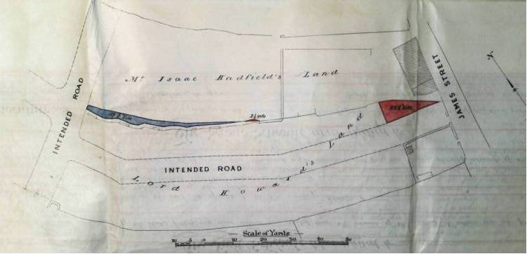
The plan below is taken from an indenture dated 21 May 1874 by which Isaac Hadfield and John (Hyde) Hadfield exchanged the land coloured blue for that coloured pink with Lord Howard of Glossop.
The house marked on the plan above the larger pink area is Churn Milk Hall.
The only photograph we have of the farmhouse (which dates from between 1903 and 1927 given the presence of the tram lines) is below. The nameplate for Hadfield Place is clearly seen on the side wall. The building (which comprised numbers 2, 4 and 6 James Street) has since been demolished and replaced with numbers 1a and 1b Hadfield Place.

Return to GJH.me Home Page, Return to Glossop Area Family Histories index, Return to Glossop Area Local Histories index.
Last updated: 22 September 2020