The Relocation of the Grab Alley Foot-bridge.
In early 1917, Francis Sumner & Co were having problems with vandalism at Wren Nest Mills and wished to divert the footpath through the adjacent fields to prevent further occurrences. The matter came before Glossop Town Council on 28 February 1917 and virtually the same (word for word) report appeared in the 2 March issues of the Glossop Advertiser and Glossop Chronicle.
A meeting of the Glossop Town Council was held in the Council Chamber at the Town Hall on Wednesday evening, there being present Ald W. White, J.P., M.D. (Deputy Mayor) presiding, Baron Doverdale of Westwood, Ald. W. Holdgate, Ald. J Malkin, Ald. L Lee, Ald. Geo. Wharmby, Councillors T. Braddock, G. Kinder, W. Jackson, W. Newton, S. Bamforth, S. Gregory, along with Mr. T. W. Ellison (clerk), Mr. S. Fletcher (Borough accountant), and Mr. S. Dane (sanitary inspector and lighting inspector).
The first item on the agenda was: Considering and ordering as to a notice from Francis Sumner and Company, Limited, under Section 84 of the Highway Act, 1835, as to the diversion, turning, and stopping up of a highway, being a public footway, commencing at a point in High Street West, Glossop, leading through certain lands of Lord Howard of Glossop, and which diverges into two branches, one of which branches extends to Dinting New Road and Higher Dinting, and the other of which branches and extends to Surrey Street and to Spire Hollin Lane, in Glossop, in the Borough of Glossop, in manner stated in the said notice, and the plan accompanying the same, and receiving the report of the sub committee appointed by the Highways, Sewage, and Buildings Committee to view the said highway, and adopting or otherwise the recommendation of the sub committee, and, if adopted, giving the necessary directions for application to be made to the Justices of the Borough of Glossop to view the said highway and authorising the Borough Surveyor to take the necessary steps to obtain the order.
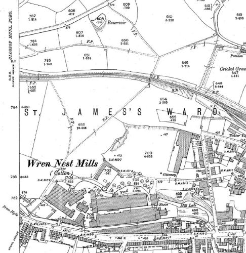
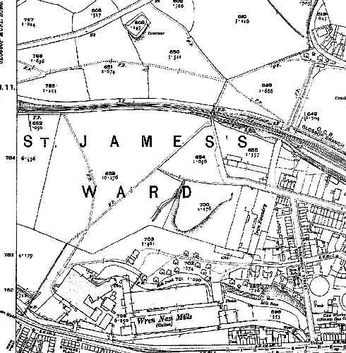
The Town Clerk, in a full statement as to the proposed diversion of the pathway, said the matter had already been before the Highways Committee, and they appointed a sub committee, which latter had viewed the site of the existing footway, which Messrs. Sumner and Co. proposed to divert, and also the site of the footway which it was proposed to substitute for it, and the sub-committee's report was to the effect that the proposed diversion was one which the Council might be recommended to sanction, and which already had the consent of Lord Howard. The footway proposed to be diverted commenced in High Street West, crossed the stream by a foot bridge below Sumner’s Mills, led on up the fields, and then branched off in two directions - one to Dinting New Road and Higher Dinting, and the other to Surrey Street and Spire Hollin Lane. It was proposed to divert the path by striking in about 30ft. lower down than the present footbridge. The length of the existing portion of the footway was 591 feet, and of the proposed new portion 590 feet. The suggested path would be fenced off, and Messrs. Sumner and Co would take a lease of the land between their premises and the suggested new footpath. The object of the diversion was to give the Mill Co greater protection of their premises, which, in the past, had been damaged by the breaking of windows, etc., through being in too close proximity to the existing path; to do away with annoyances to pedestrians; and improve the facilities for police supervision, the corner which at present existed, having, in the past, been a happy hunting-ground for youthful gamblers, etc. That briefly, was the scheme and what the Council had to do was to approve the action of the sub-committee, and instruct the surveyor to take the necessary steps to secure the diversion of the path.
Mr. Ellison then proceeded to explain the necessary procedure, and added that the costs incurred and payable by the Council would be defrayed by Messrs. Sumner and Co.
Coun. Bamforth: Will it be the same foot bridge?
The Clerk: Yes, if it is suitable.
Coun. Bamforth: It is only to be a foot bridge?
The Clerk: That is all.
Ald. Holdgate: I believe it is being done to make the mill more private.
Ald. Wharmby moved, and Coun. Bamforth seconded the necessary motion, which was carried.
The 1897 OS map, on the left, shows Grab Alley foot-bridge opposite the end of Spring Street. The 1919 OS map, on the right, shows it shifted westwards.
The differences in the footpath layouts can also be seen by comparing the maps.
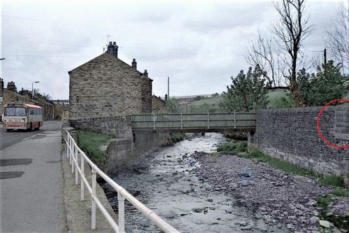
Shortly after publishing this article I was contacted by Vincent Sayers, who grew up in a house a few doors down from the Grab Alley footbridge.
He wished to alert me to the photo above, which he had coloured from a monochrome original taken by the late Glossop photographer Cliff Hales.
Toward the right of the photo, circled in red, the stonework is different. It seems likely that this is where the original bridge was moved from.
Return to GJH.me Home Page, Return to Glossop Area Local Histories index.
Last updated: 2 June 2023